Drones Flying Over NJ: A Practical Guide for Beginners
Explore what drones are flying over New Jersey, how to read airspace, licensing needs, privacy considerations, and best practices for safe, compliant flights.

Over New Jersey, drones overhead fall into three broad categories: hobbyist quadcopters, commercial inspection drones, and occasional public-safety aircraft with authorization. The exact set of aircraft above NJ changes by time and location, but FAA rules, LAANC access, and local ordinances shape every flight. Stay aware of airspace limits, TFRs, and property boundaries to fly safely.
what drones are flying over nj
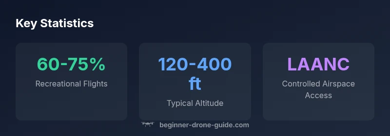
New Jersey presents a diverse airspace environment, and the drones you see overhead reflect a mix of hobbyist quadcopters, commercial inspection drones, and public-safety aircraft during special operations. The question "what drones are flying over nj" is common among observers trying to understand who is up there and why. In practice, a large portion of flights are recreational, using small quadcopters for photography, landscape shots, or learning to fly. Commercial operators might perform building inspections, power-line surveys, or municipal surveillance flights, while emergency or law-enforcement drones appear only when authorized for specific missions.
According to Beginner Drone Guide, the drone landscape over NJ is shaped by FAA rules, LAANC access, and local ordinances. Operators must stay within the boundaries of airspace classes they are allowed to fly in and respect temporary restrictions such as NOTAMs and event-based closures. The key takeaway for beginners is not to guess based on what you see; verify airspace status, ensure you’re within visual line of sight, and always register your drone if required. By combining airspace literacy with practical safety habits, you can interpret who is overhead and how to fly responsibly.
NJ airspace structure and how it affects overhead flights
New Jersey’s airspace is a patchwork of classes, controlled zones, and temporary restrictions. Most of the state operates in Class G when far from airports, but near hubs like Newark Liberty International and Atlantic City International, classes B or C may limit operations without proper authorization. Temporary Flight Restrictions (TFRs) can arise around major events, VIP movements, or safety incidents. Before any flight, consult FAA UAS maps, local NOTAMs, and consider LAANC authorization if you plan to operate in controlled airspace. Understanding these distinctions helps you anticipate what drones are flying over NJ and where you can legally operate. Local municipalities might impose privacy or nuisance rules that affect flight paths, so check city ordinances and state guidance for best results.
Practically, successful planning hinges on knowing the airspace class first, then confirming you have the necessary permissions. If you’re in doubt, stay in open Class G areas far from airports. In such zones, you’re less likely to encounter restricted airspace overhead, which often makes it easier to stay compliant while observing safe flight practices.
How to spot drones overhead: signals and tools
To learn what is overhead, use a combination of visual cues and official tools. Look for FAA-reported advisories, such as NOTAMs or TFRs, and listen for airspace activity around busy corridors. Leverage beginner-friendly apps and maps like the FAA UAS Data Map and B4UFLY to check current airspace classifications before each flight. LAANC-enabled pilots can obtain near real-time authorization for controlled airspace, reducing the guesswork on what drones are overhead. In addition, local news or community boards often share information about public-safety or event-related drone flights. Always cross-check your planned flight path against airspace status and ensure you’re flying within visual line of sight. Consistently applying these checks keeps you compliant and reduces the likelihood of an unexpected encounter overhead.
Pro tip: maintain a habit of running through a quick preflight airspace check if you are near airports or populated coastal towns where activity varies by time of day.
Licensing, registration, and training requirements for NJ pilots
Anyone piloting a drone in NJ should understand the licensing landscape. Recreational pilots must adhere to FAA rules, complete a knowledge-based test, and register drones that weigh over the FAA threshold (commonly 0.55 pounds). Commercial operators typically need a remote pilot certificate under Part 107 and must obtain LAANC authorization to fly in controlled airspace. Training emphasizes flight safety, privacy, and regulatory awareness. For beginners, investing time in basic flight training, understanding wind and weather, and practicing in open spaces helps build a solid foundation before venturing into complex NJ airspace.
NJ-specific considerations can include additional local permitting or event-based restrictions, so always verify any city or county requirements before a flight. Keeping a proactive mindset about licensing and training increases your safety margin and reduces regulatory risk.
Privacy and property considerations when drones fly over NJ
Flying over NJ requires awareness of privacy and property rights. Avoid intrusive photography of individuals without consent, and be mindful of sensitive locations such as schools, hospitals, and private residences. NJ residents are protected by general privacy laws and nuisance regulations, which can apply to drone operations. Whenever possible, fly at altitudes and routes that minimize exposure to private property, and consider notifying property owners if your flight passes near a private yard or business. Clear communication and responsible flight behavior help sustain positive community relations and reduce complaints about drone activity overhead.
Additionally, be mindful of wildlife, critical infrastructure, and environmental protections that may impose incidental restrictions. Responsibility and respect for neighbors and property owners are essential as you learn to navigate NJ airspace.
Real-world uses in New Jersey: inspections, real estate, events
New Jersey presents a wide range of real-world applications for drones. Real estate photography benefits from elevated views of coastal properties and urban neighborhoods, while infrastructure inspections (bridges, power lines, and rail corridors) rely on stable flight and high-resolution imagery. Public-facing events, such as boardwalk festivals or sports gatherings, often require coordination with authorities and approved flight plans. In coastal areas and near industrial zones, drones support environmental monitoring, flood assessments, and shoreline surveys. Understanding which drones are overhead in these contexts helps you anticipate activity patterns and identify common flight scenarios you might observe while practicing in NJ.
To maximize value and safety, always align your flight plan with approved use cases, respect airspace restrictions, and be prepared to adjust or pause flights during crowded events or heavy air traffic.
Safety protocols and best practices for beginners in NJ airspace
Safety should be your top priority when flying in NJ. Start with a preflight checklist that includes verifying airspace status, updating firmware, checking weather conditions, and confirming battery health. Practice in open, unobstructed spaces away from crowds and sensitive infrastructure. Maintain visual line of sight, use a recorder for flight logs, and be ready to land immediately if airspace status changes or if a bird or man-made obstacle appears. In NJ, weather can shift rapidly near coastlines and urban canyons, so be prepared for sudden winds or gusts. Always have a clear return-to-home plan and a designated landing zone to prevent accidents. Following these safety habits helps you stay compliant while growing your piloting skills.
Planning and preflight checklist for NJ flights
Before every flight over NJ, run a concise preflight protocol: confirm airspace classification via FAA maps and NOTAMs, verify drone registration, review weather, set height and distance limits, and decide on a return-to-home threshold. Check for local ordinances or event-based restrictions in the area and have a documented flight plan if flight in controlled airspace is necessary. Carry emergency contact information and a basic first-aid kit, and ensure you have a suitable protector for propellers during handling. Finally, log the flight details after each session for regulatory and personal safety tracking.
Overview of NJ drone airspace and operational considerations
| Category | Observation | Regulatory Note |
|---|---|---|
| Airspace | Class G predominant; near airports, controlled zones appear | FAA LAANC authorization required in controlled airspace |
| Flight types | Recreational, commercial, public-safety | Licensing and registration may be required depending on use |
| Operational constraints | No-fly zones, TFRs, NOTAMs | Always check airspace status before flight |
Frequently Asked Questions
Do I need FAA authorization to fly a drone over NJ airspace?
Authorization depends on the airspace. In controlled airspace, commercial flights typically require LAANC authorization and proper remote-pilot licensing; recreational flights must comply with FAA rules and drone registration. Always verify airspace status before flight.
Authorization depends on the airspace. In controlled areas, you may need LAANC and a remote-pilot certificate; otherwise, follow FAA rules and register your drone.
What are the typical no-fly zones in NJ?
No-fly zones usually surround major airports, sensitive infrastructure, and large events. Always check NOTAMs and use official airspace maps before flying.
No-fly zones cover airports and sensitive sites; check NOTAMs and airspace maps before you fly.
How can I check NJ airspace before flight?
Use the FAA UAS Data Map and B4UFLY app, plus LAANC when you need access to controlled airspace. These tools help you confirm current status and obtain necessary permissions.
Use FAA maps and LAANC to verify airspace and get permissions before you fly.
Are there privacy concerns when drones fly over NJ?
Yes. Respect privacy; avoid recording people without consent and be mindful of private property rights and local privacy laws.
Yes—privacy matters. Respect people and private property when you fly.
What equipment should a beginner bring for NJ flights?
Register your drone, carry line-of-sight awareness, check weather, and bring basic safety gear and a means to record flight details for accountability.
Register your drone and bring basic safety gear and weather awareness.
Where can I learn more about NJ-specific drone regs?
Consult FAA resources, NJ state and local agencies, and trusted guides like Beginner Drone Guide for practical steps.
Check FAA and state resources and trusted guides for NJ rules.
“Drones over NJ succeed when pilots plan ahead, stay compliant with airspace rules, and practice responsible flying around people and property.”
Quick Summary
- Know airspace limits before you fly
- Always check NOTAMs and use LAANC where required
- Respect privacy and property when flying over NJ
- The Beginner Drone Guide's verdict is to plan meticulously and fly with respect for NJ airspace