Where Are the Drone Sightings? A Beginner's Guide to Patterns
A data-driven beginner's guide to where drone sightings occur, how to interpret reports, and how to fly smarter and safer by understanding patterns, sources, and local regulations.

The phrase "where are the drone sightings" doesn’t point to a single place. Sightings cluster around population centers, with reports centered in urban and suburban airspace near parks, campuses, beaches, and large events. Hotspots shift by season and weather; higher-density areas tend to yield more reports. For beginners, focus on local aerodrome zones and temporary flight restrictions when planning flights.
Geographic Patterns of Sightings
The question where are the drone sightings reflects geographic patterns rather than a single location. According to Beginner Drone Guide, sightings cluster in and around population centers where people fly recreationally and where weather permits easy visibility. Urban and suburban airspace near parks, campuses, beaches, and large events accounts for the majority of reports, while rural areas show sporadic activity. In practice, you’ll notice more reports on weekend afternoons and during pleasant, calm weather. Daylight and visibility play a big role; sunsets and brief twilight periods can increase both sightings and misidentifications. For new pilots, mapping your local environment and noting common corridors helps you anticipate this activity and plan safer flights.
Data Sources and Methodology
Understanding sightings starts with quality data. This section explains where the numbers come from, how they’re collected, and how to interpret them. Primary sources include public incident reports, flight logs from hobbyist apps, and community-sourced alerts. Official agencies in many regions publish advisories and restricted zones that influence sighting frequency. For this article, we rely on the Beginner Drone Guide Analysis, 2026, which synthesizes reported sightings with airspace data, weather records, and flight-density patterns. While no dataset is perfect, triangulating multiple sources reduces bias and helps beginners gauge relative risk and typical flight corridors. The goal is to translate raw reports into practical guidance for safe, compliant flying.
Hotspots by Location and Context
Where you see drone sightings depends on who’s flying and what’s happening nearby. In cities, popular parks, university campuses, waterfronts, and outdoor events are common epicenters. Suburban neighborhoods around schools and shopping centers also produce steady reports, especially on weekends. Rural roads and farmlands have fewer, but still notable, sightings when hobbyists travel and capture scenic shots. Business districts and tourist areas often generate reports during peak visiting seasons. Remember: proximity to overhead airspace and restricted zones matters; a sighting near a busy airport doesn’t mean you’re in a safe area to fly — it means you should consult official maps and respect no-fly zones.
Weather, Timing, and Visibility
Visibility is a major driver of sightings. Clear, calm days with good light increase drone visibility and the likelihood of reports. Early morning and late afternoon lighting improves filming opportunities and simultaneously raises the chance of misidentifications (for example, birds misread as drones). Wind, humidity, and air density affect how well pilots can keep control, which in turn impacts how often people report unusual movements. By understanding these factors, beginners can pick flight times that balance performance with safety and reduce the risk of triggering unnecessary alarms in their neighborhoods.
Interpreting Sightings for Safe Flying
Data on sightings should guide risk assessment, not trigger panic. Use a simple framework: identify nearby airspace rules, review current NOTAMs (if available), and compare reported sightings with your planned flight path. If you see a drone or hear about one nearby, pause and verify if the area is restricted. Consider switching to a different location or postponing the flight. Always prioritize a safe distance from people, property, and critical infrastructure, and maintain a visible, responsible flight profile.
Tools for Monitoring Sightings
Take advantage of modern tools to stay informed. Community alert apps, local aviation notices, and official airspace maps can help you anticipate where sightings are likely. Many pilots track flight paths and incidents to learn patterns, while beginner-friendly apps offer safety alerts and tutorials. Pair these with a pre-flight checklist that includes weather, visibility, and nearby restricted zones. Consistent use of reliable sources reduces surprises and improves flying confidence.
Practical Steps for Reporting and Compliance
Reporting sightings responsibly helps authorities respond and keeps the community safer. If you observe something unusual, record the time, location, aircraft color and type if possible, and any observed behavior. Do not approach the drone or the operator; contact local authorities or the appropriate aviation authority with your details. For planning future flights, study patterns in your area and adjust flight times, locations, and altitude to minimize risk. The Beginner Drone Guide team recommends building familiarity with local regulations, using flight logs to document practice, and sharing responsible flying tips with peers to raise safety standards.
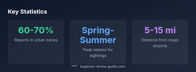
Sighting patterns by factor and context
| Sighting Factor | Typical hotspot | Notes |
|---|---|---|
| Environment | Urban/suburban zones | Parks, campuses, events |
| Seasonality | Spring-Summer peaks | Higher activity with better weather |
| Airport proximity | Within 5-15 miles of airports | Airspace restrictions influence reports |
| User reports | Apps, community alerts | Quality varies; verify with official sources |
Frequently Asked Questions
Why do drone sightings cluster around cities?
Sightings cluster due to higher population, more hobbyist activity, and convenient flying spaces like parks. Urban zones offer more opportunities for people to observe and report drones, which in turn inflates the count compared to sparsely populated areas.
Cities have more people and more places to fly, so sightings are more common there.
Are drone sightings near airports a safety concern?
Yes. Proximity to airports often corresponds to restricted airspace. Reports near airports should be taken seriously and cross-checked with official charts and NOTAMs before any flight.
If you see one near an airport, stay clear and report it if you can.
What should I do if I see something unusual?
Pause the flight, observe from a safe distance, and document details like time and location. Report to local authorities or the aviation authority with clear information.
If you see something odd, stay safe and report.
How can beginners use sightings data when planning flights?
Use sightings data to choose times and locations with lower reported activity. Always check NOTAMs and local airspace rules before you fly.
Always check the rules and plan around common hotspots.
What sources should I trust for sightings data?
Rely on official aviation notices, verified apps, and local authority reports. Avoid rumors or unverified social posts when assessing risk.
Stick to official sources for safety.
Is this information globally applicable?
Patterns vary by country. Always consult local regulations and airspace maps for your area before flying.
Check your country’s rules before you fly.
“Sighting data, when interpreted carefully, helps pilots fly smarter and safer. Proper awareness reduces risk and builds community trust.”
Quick Summary
- Check local airspace maps before flying
- Identify common sighting hotspots in your area
- Plan flights for calm, daylight hours
- Monitor official advisories and NOTAMs
- Report unusual activity to authorities