How to Use a Drone to Find Deer: A Beginner's Guide
Learn practical, beginner-friendly steps to use a drone for locating deer, including safety, legal considerations, habitat indicators, and ethical field practices for forests and fields.

To effectively use a drone to find deer, plan habitat scouting, wind-safe flight paths, and wildlife-friendly observation. This quick answer covers essential gear, legality, and how to read aerial indicators like habitat patches, tracks, browse lines, water sources, and feeding sites. It also notes ethical considerations and what to document during a hunt or survey. By starting with permissions and a clear plan, you’ll maximize your chances while minimizing disturbance.
Why a drone helps locating deer
Deer are masters of cover; they blend into woodland edges, fields, and grasses. For beginners, a drone can be a powerful observation tool to complement ground scouting. The drone-to-find-deer concept has gained popularity among wildlife watchers who want noninvasive ways to gather early-season intel. Aerial vantage points reveal habitat features deer favor—edges of clearings, hedgerows, water sources, and sunlit patches where forage concentrates. With a well-planned flight, you can locate fresh tracks, bedding areas, and feeding trails without stepping on the ground, reducing disturbance in sensitive habitats. This approach is especially helpful when you are learning how to identify sign and track patterns. Before you fly, ensure you are compliant with local airspace rules and wildlife protection guidelines; even beginner drones can disrupt wildlife if misused. According to Beginner Drone Guide, success comes from preparation, ethics, and a clear objective. Use the drone to gather context that grounds your on-ground observations, not to replace careful, slow searching.
Understanding deer habitat and flight planning
Deer habitat varies by region and season, but several constant principles apply when you’re planning a drone-assisted search. The drone’s role is to map potential hotspots such as water sources, browse lines, field edges, bedding pockets, and likely travel corridors. Planning a flight means timing it for when deer are most active in your area, aligning your takeoff site with safe access, and establishing a clear wind direction to minimize disturbance. A practical plan includes defined boundaries, safe takeoff and landing zones, and an abort mechanism if wildlife or people come into the area. You should also verify airspace restrictions and any temporary flight restrictions near protected lands. The plan should account for daylight visibility and camera settings to maximize target detection through contrast. Based on Beginner Drone Guide analysis, breaking the search into sectors improves coverage and reduces missed signs. Carry spare batteries and a lightweight log to mark surveyed areas for follow-up ground-truthing.
Choosing the right drone and sensors
For beginner wildlife work, you want a drone with stable flight, reliable stabilization, and a camera capable of high-resolution imagery. An RGB camera helps identify habitat features, tracks, and feeding sites, while a thermal imaging sensor can be a game changer for dense cover or low light conditions. If you can access thermal, plan ahead for how to interpret heat signatures as potential deer presence rather than ambient warmth. A good gimbal provides smooth footage, which aids in later analysis. Battery life determines how much ground you can cover per flight, so plan for extra batteries and a lightweight carry setup. Ensure you have a dependable flight controller, obstacle avoidance if available, and basic safety features like automatic return-to-home and geofencing. The goal is a balance of price, safety, and data clarity; start with a solid, simple kit before expanding capabilities.
Preflight and legality checks
Preflight work is about risk reduction and compliance. Check the weather and visibility, set a safe altitude range, and choose a takeoff point free of people and livestock. Update firmware, calibrate compass and IMU, and verify GPS lock. Make sure you carry any required permits, registrations, or waivers for your region, and respect wildlife and privacy concerns relevant to your area. Data organization matters too: label SD cards, back up footage, and decide how you will log observations from the drone. If you’re unsure, err on the side of caution and pause the mission. Clear objectives and documented permissions reduce risk and frustration, per Beginner Drone Guide. When flying near sensitive habitats, keep altitudes conservative and avoid hovering directly over animals to minimize stress.
Planning flight paths and search patterns
Systematic coverage is the backbone of a successful drone-assisted deer search. Use a grid or transect pattern to ensure no area is left unchecked, or employ a serpentine path when terrain is irregular. Maintain a steady altitude and consistent overlap between passes to avoid gaps in coverage. Waypoints are helpful for replaying the same route in future sessions, enabling comparison over time. Label sectors with landmarks, approximate coordinates, and notes on any wildlife signs you observe. Prepare for contingencies such as unexpected weather shifts or no-fly zones. According to Beginner Drone Guide, replicable patterns build a reliable dataset and reduce operator bias. A well-planned route minimizes wasted flight time and improves the likelihood of spotting deer signs such as tracks, bed areas, and foraging zones.
Conducting safe and effective aerial searches
Begin with a cautious, slowed approach that prioritizes safety and wildlife comfort. Use conservative speeds and deliberate passes to maximize image quality while reducing disturbance. Keep a constant line-of-sight and avoid aggressive turns or sudden elevators that could frighten nearby deer. Document movement or signs with still photos and short clips, focusing on contexts like water sources or feeding patches. If detection is uncertain, widen the search radius in subsequent passes and compare against your habitat map. Always monitor battery levels and have a ready plan to return if conditions deteriorate. A safety-first culture ensures you remain compliant and opportunistic when a deer is visible from above.
Reading signs from the air and ground-truthing
Aerial observations can highlight movement and habitat preferences that ground scouts might miss. Look for shifting bedding areas along forest edges, fresh tracks near water, and browse height changes on shrubs and saplings. Ground-truthing validates aerial cues by confirming signs on the ground and updating your records accordingly. When possible, coordinate a careful, minimal disturbance ground check after an aerial pass. Inconsistent signs can occur due to weather or recent human activity, so you should revisit ambiguous sites later. The practice of cross-referencing air data with ground evidence helps refine future flights and strengthens your overall deer-tracking approach.
Data management, ethics, and sharing results
Handle all data responsibly; store images and coordinates securely and avoid public sharing of sensitive wildlife locations. Respect private property and obtain permissions before approaching lands. Document your methods, weather, and wildlife observations to support a transparent workflow. If results inform hunting or land management decisions, ensure you comply with ethical standards and legal requirements. Transparency builds trust with landowners, wildlife managers, and fellow hobbyists. The Beginner Drone Guide emphasizes that responsible data practices and clear reporting elevate your credibility and safety when using drones to find deer.
Real-world tips and common mistakes to avoid
Focus on maintaining a wildlife-friendly approach: stay at elevations that reduce noise, use wind direction to minimize scent cues, and align flight times with peak wildlife activity. Common mistakes include neglecting airspace checks, rushing searches, and failing to log data consistently. Always test equipment before critical missions and practice in non-wildlife contexts to build muscle memory. Good habits compound: methodical coverage, careful data logging, and ongoing learning lead to steady improvements in your ability to locate deer signs from the air.
Quick-start checklist and next steps
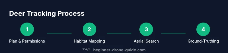
Before your first reconnaissance flight, assemble your gear, verify permissions, and define clear objectives. Create a simple habitat map of the area, mark potential deer hotspots, and plan a conservative flight that minimizes disturbance. After the flight, review footage, annotate signs, and schedule a quick ground-truth session if necessary. Finally, recap what you learned and adjust your plan for the next session. This iterative approach helps you grow from a novice to a confident deer-tracking operator over time.
Tools & Materials
- Drone with stable gimbal(3-axis gimbal recommended for smooth footage)
- Spare batteries(At least one extra battery per flight)
- High-resolution camera (RGB) or thermal sensor(Thermal helps in dense cover or low light)
- GPS-based flight controller(Built-in or external module)
- ND filters (optional)(Reduce glare in bright conditions)
- Memory cards and data cable(For data logging and backup)
- Maps/field notebook(Log coordinates and observations)
- Ground markers/flags (optional)(Mark hotspots for later ground-truthing)
- Weather app or forecast tool(Plan around stable conditions)
- Permits/registrations(Carry documents during flights)
Steps
Estimated time: 45-60 minutes
- 1
Verify legality and objectives
Check local laws and wildlife guidelines; define a clear observation objective for the session to guide your flight plan.
Tip: Always confirm airspace permissions before takeoff. - 2
Prepare gear and safety plan
Inspect your drone, verify batteries, and set a safety plan that includes escape routes and emergency procedures.
Tip: Charge batteries fully and carry spares. - 3
Plan flight path and search area
Draft a grid or transect route aligned with likely deer habitat, mark takeoff site, and set waypoints for repeatability.
Tip: Document sectors with landmarks for easy ground-truthing. - 4
Calibrate sensors and settings
Calibrate compass/IMU and set camera parameters for optimal contrast; enable return-to-home in case of signal loss.
Tip: Test a short, non-wildlife flight to confirm settings. - 5
Execute aerial search
Launch and follow the planned pattern with steady speed and consistent overlap to maximize coverage.
Tip: Keep line-of-sight and avoid hovering over animals. - 6
Record observations and signs
Log any deer signs, capture clear frames, and note date, time, weather, and position.
Tip: Capture context shots showing habitat features. - 7
Ground-truth and plan follow-up
Return safely, review aerial signs on the ground, and plan any follow-up visits with minimal disturbance.
Tip: Respect private lands and wildlife safety at all times.
Frequently Asked Questions
Is it legal to use a drone to find deer?
Laws vary by jurisdiction. Always verify airspace permissions, hunting or wildlife regulations, and privacy requirements before any flight. A drone should never be used to hunt or harass wildlife, and you must carry any required permits or registrations.
Check local laws and obtain permissions before flying. Never hunt or harass wildlife with a drone.
What drones work best for wildlife tracking?
A stable, easy-to-fly platform with a good camera is ideal. If possible, add thermal imaging for dense cover and ensure reliable battery life for longer sessions.
Look for stability, a good camera, and thermal options if you’ll be tracking wildlife in dense cover.
Do I need permits to fly on public lands?
Yes, most public or protected lands require permits or special authorization. Always consult the managing agency and respect seasonal restrictions and protected wildlife zones.
Check with the managing agency for permits and seasonal restrictions.
How can I minimize disturbing deer during flights?
Fly at conservative altitudes, move slowly, and avoid lingering over bedding areas or feeding sites. Maintain noise discipline and respect the animals’ space.
Keep distance, move slowly, and avoid staying over deer for long.
What should I do if I can’t locate deer after a flight?
Review habitat indicators, cross-check with ground signs, and adjust search patterns. Sometimes deer activity shifts with weather or time of day, so plan a follow-up window.
If you don’t see deer, reassess habitat cues and try a different search window.
How should I share findings responsibly?
Share results with landowners and wildlife managers only, avoiding sensitive locations. Document methods clearly and emphasize safety and ethics.
Share with landowners or wildlife managers and keep locations private when needed.
Watch Video
Quick Summary
- Plan ahead with permissions and a clear objective
- Fly slowly and respect wildlife to minimize disturbance
- Document signs and log data for ground-truthing
- Review results and adapt your search plan